Search the Collection:
Artwork copyright Cynthia Krieble. Photo courtesy of the artist, 2002.
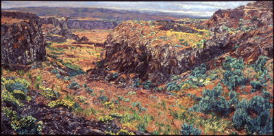
Scablands
“This collection consists of landscape paintings by Washington artists that pay tribute to the vast and strange beauty of Washington’s Channeled Scablands and the surrounding areas formed by the Ice Age floods.
I lived in Washington State for over a decade before I discovered the beauty of the Scablands. I find that this region is one of the least-known wonders of our state, certainly to outsiders, but even for many who live here. There is nothing else quite like it in the United States.
The Missoula Floods were a series of massive Ice Age glacial lake outbursts that swept across Eastern Washington approximately 15,000 years ago. They formed what we now know as the Channeled Scablands and the Columbia River Gorge, and all the associated land formations, such as Grand Coulee, Palouse Falls, Dry Falls, Drumheller Channels, potholes, and current ripples.
I hope that these paintings will inspire Washingtonians to visit, or revisit, this region.”
–Curated by Aaron Semer, ArtsWA Creative Districts Program Manager. Aaron is a singer/songwriter who has performed all around Washington State, from Seattle and Yakima folk festivals to Woody Guthrie Day at Grand Coulee Dam. He recently worked on the successful relaunch of Bumbershoot Arts & Music Festival. (May 2025)
The Channeled Scablands extend from the area around Spokane in Northeastern Washington, west to the Columbia River near Vantage on the eastern edge of the Cascade Mountains in Central Washington, and south to the Snake River near Pasco in Southeastern Washington. It is a rocky, flat landscape crisscrossed with channels called “coulees”, large rock basins, and flat-topped hills called “buttes”. There are about 150 coulees – the biggest being over a hundred feet deep and over 30 miles long. The buttes range in height from 98 to 328 feet. And the rock basins range in width from 33 feet to 7 miles, and up to 100 feet deep.
Read Less
